Humanitarian work is dangerous. Delivering food through conflict zones, minefields, or flash floods can kill aid workers. Now, tech adapted for Mars is coming home to save lives.
Project AHEAD is a joint effort by the World Food Programme (WFP), Germany’s DLR, the Red Cross, and tech partners. They are building remotely operated vehicles for places too risky for humans.
“Right now, there aren’t really systems integrated into these emergency protocols in many countries.” — Monique Kuglitsch
How remote control replaces risk on the ground
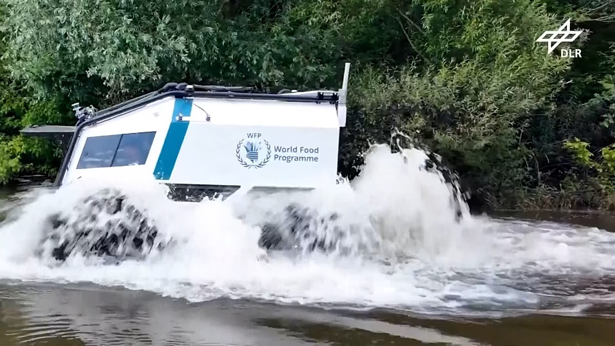
Footage from DLR shows a SHERP all-terrain truck in a German test site. It drives through open water. It climbs rough rocks.
The driver is not in the vehicle. Sensors scan the path ahead. An operator controls the machine remotely.
This tech comes from deep space. DLR developed planetary rovers like the MMX rover for Phobos, Mars’s moon. Now that autonomy moves aid into danger zones. No pilot needed in the cab.
Tracking hunger before it gets worse
Delivery isn’t the only fix. We also need to predict where hunger strikes.
The WFP launched HungerMap Live. It is a free platform. It uses machine learning to track food insecurity in over 95 countries.
Data points include conflict. Weather matters. Climate hazards and economic conditions feed the algorithm. The goal is simple: spot crises early.
Bernhard Kowatsch leads the WFP’s Global Accelerator division. He notes they are testing forecasts for the next 90 days. Real-time data helps us see the next wave of starvation coming.
Why AI maps are faster than human volunteers
Maps are vital in disasters. Without road data or building locations, aid workers are blind. They don’t know where to evacuate or deliver supplies.
Take the earthquakes in northern Venezuela this June. Damage assessment was slow. Geographical data was thin.
The Humanitarian OpenStreetMap Team (HOT) stepped in. They used machine learning on satellite imagery to find buildings. Volunteers used the MapSwipe app to check them.
Leen D’hondt heads technology at HOT. She says they mobilized 600 volunteers in four days. They swiped left or right on mobile screens. Yes, damaged. No, intact.
This speed helped early responders target food deliveries correctly.
Is AI replacing humans? No. Not yet.
D’hondt argues manual mapping offers better quality. But speed wins in the immediate aftermath of a quake.
“Sometimes it’s more important to know more or Less where the buildings are,” D’hondt said.
The buildings might not be perfectly mapped. But we know how many people live there. That’s where machine learning fits in now.
The state of emergency integration
These systems aren’t standard yet. Insiders say integration into global emergency protocols remains low.
Exceptions exist. India uses an AI early-warning system that works daily. Europe uses an AI forecasting system from the European Centre For Medium-Range Weather Forecasts. It’s operational.
Most other countries? Still experimental.
Monique Kuglitsch manages innovation at the Fraunhofer Heinrich Hertz institute. She notes the gap between lab tests and field use.
Technology can reshape aid. It pulls humans out of fire. It predicts famine. But the infrastructure to support it is still catching up. We have the tools. The protocols are still being written.